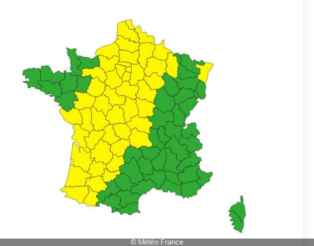
Will thunder rumble this Tuesday, June 18, 2024 in Paris and the Île-de-France region? It's likely. New thunderstorms could hit parts of the country at the start of the week. For this reason, Météo France has placed around 50 French departments under yellow alert for thunderstorms on June 18.
In detail, a large part of France, from the southwest to the north, has been placed under yellow alert forthunderstorms. Pyrénées-Atlantiques, Lot-et-Garonne, Gironde, Charente-Maritime, Seine-Maritime, Pas-de-Calais, Ardennes, Puy-de-Dôme, Meuse and Oise have been placed on yellow alert for the risk of severe thunderstorms this Tuesday. "There is arisk of strong thunderstorms over the country in several waves, from late Monday night into Tuesday evening" warns Météo France, adding that"heavy rainfall and hail are to be expected".
"This day will see a very strong conflict of air masses over France, with a blast of very strong heat to the east. As a result, violent thunderstorms are expected from the southwest to the northeast," announces La Chaîne Météo on its website.
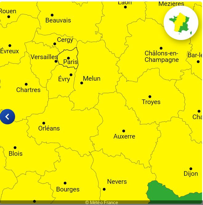
What's the weather like in Paris and the Ile-de-France region? The capital and the 7 other departments of the Ile-de-France region (Seine-et-Marne, Yvelines, Essonne, Hauts-de-Seine, Seine-Saint-Denis, Val-de-Marne and Val-d'Oise) have also been placed on yellow alert for thunderstorms by Météo France this June 18. Météo France is forecasting an"active rainstorm expected in the early morning, with locally marked rainfall intensities (even a little hail in places)", followed by a"lull during the day, then more uncertainty about the potential thunderstorm risk at the end of the day and evening".
According to Météo France, thunderstorms could hit all the departments in the Paris region this Tuesday morning between 6 and 11 am, then again at the end of the day, between 5 pm and midnight.
Residents and visitors to the region are advised to remain vigilant, follow updates from Météo France and take the necessary precautions to protect themselves from these severe weather conditions.
During this period of bad weather, Météo France advises you to watch out for thunderstorms, which are synonymous with danger. Here are a few recommendations to follow as a precaution: