
After a period of high-pressure, spring-like weather settled over France, disturbances are making a comeback as the week comes to an end. According to Météo France, a new front will sweep across the northern and western parts of the country on Friday, March 13, 2026. “It’s quite active, bringing heavy rain at times and wind gusts of 50 to 70 km/h inland,”” reports the meteorological service.
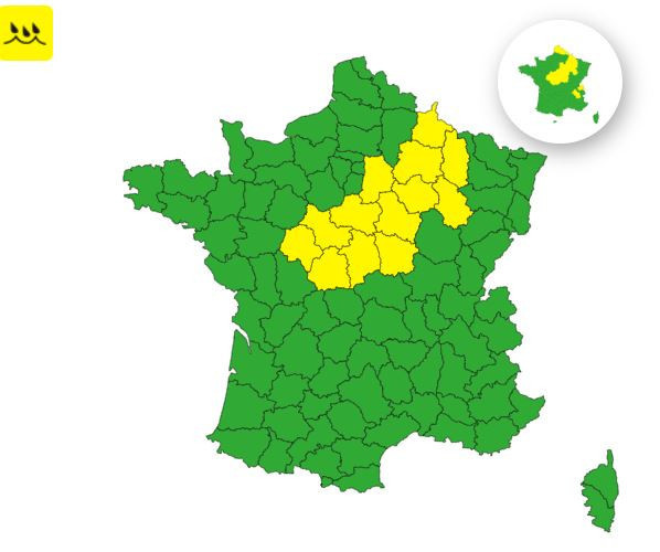
Some regions are expected to be hit harder than others. Weather France has issued a yellow alert for rain and flooding across 13 departments in mainland France on March 13. Specifically, the departments of Indre, Indre-et-Loire, Cher, Loir-et-Cher, Loiret, Nièvre, Yonne, Aube, Marne, Haute-Marne, Meuse, and Ardennes are all under this yellow alert.
The last department to be placed under yellow vigilance for heavy rainfall and flood risk is located in Île-de-France. It is Seine-et-Marne. According to the meteorological service, the highest rainfall accumulations are expected in this Île-de-France department starting this Friday from 3 p.m. These showers are forecast to continue into the afternoon and evening.
According to Météo France, " heavy rainfall can have serious consequences for the safety of people and property. It may lead to flooding caused by runoff or overflowing rivers." Additionally, motorists are urged to exercise the utmost caution during heavy rain. " Even moderate rain can reduce visibility and make it harder for drivers to see and be seen," warns the weather service. They also emphasize that " driving at high speeds increases the risk of hydroplaning and the danger involved."
Official website
meteofrance.com